It is more like a terrestrial landscape than a Martian one.

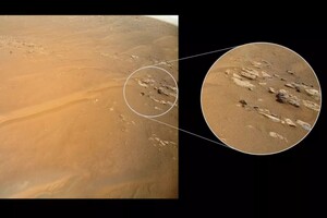
Martian Ingenuity Helicopter > recovered from a recent communication failure and transmitted to Earth an image of a ridge on the Red Planet. According to Space.com, the helicopter took a picture of a rocky ledge, which was named “Fortune Ridge” in honor of the county in Norway.
The photo was taken on April 23 during the 27th flight to Mars. The NASA Jet Propulsion Laboratory noted that the sloping layers of this region are a rarity for the Red Planet. They are much more common on Earth, as the slope is formed by plate tectonics and earthquakes.
Read also: In the photos of Mars found “the door to the underground temple”
In the future, scientists plan to compare this “fresh” image with another “sloping ridge line”, which was also found in the Jazero crater, which is exploring the rover Perseverance and Ingenuity. Researchers believe that comparing the two images taken by helicopter will help to understand how the bottom of the crater was formed and what forces acted billions of years ago.
Ingenuity recently experienced a communication failure, which researchers believe was caused by a lot of dust in the atmosphere. The mission team re-established contact with the helicopter on May 5 after it missed a “call” two days earlier. Initial analysis of the data showed that the high concentration of dust combined with low temperatures prevented the helicopter from contacting the base station located on the rover, which transmits information to Earth.
Dust reduces the helicopter's ability to recharge its solar panels, except Ingenuity briefly lost the ability to set the exact time on Mars, so it missed the season of communication with the rover. on which Ingenuity also got. At the time of the photo, the rover was four meters away from the helicopter.


